Fishing on Prairie Lake
Information on Prairie Lake from MN DNR
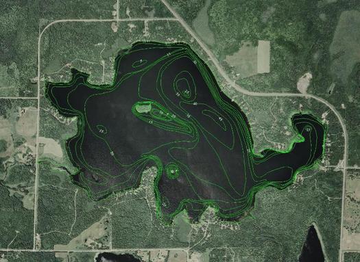
Lake Name: Prairie
Area: 794 acres
DNR DOW#: 69084800
Where? UTM Coordinates:
x:507337.890625
y:5181966.796875
Geographic Coordinates:
lat: 46.791209
lon: -92.903855
County: St. Louis
PLS identifier: T50 R20 S29
Lake Name: Prairie
Area: 794 acres
DNR DOW#: 69084800
Where? UTM Coordinates:
x:507337.890625
y:5181966.796875
Geographic Coordinates:
lat: 46.791209
lon: -92.903855
County: St. Louis
PLS identifier: T50 R20 S29
Fishing
DNR’s “Lake Management Plan” for Prairie Lake (DNR # 69084800) has long range goals to manage for walleye and quality northern pike populations. The DNR will continue to stock 1.3 million walleye fry every other year.
The regulation limits northern pike to a single fish at least 30” long.
Black crappies are relatively abundant.
Sunfish are limited but larger in size.
Yellow perch are small but average in abundance.
Largemouth bass are quite few.
